


Voting District 21530, Los Angeles County, California
About
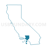
Outline

Summary
| Unique Area Identifier | 533670 |
| Name | Voting District 21530 |
| County | Los Angeles County |
| State | California |
| Area (square miles) | 0.34 |
| Land Area (square miles) | 0.34 |
| Water Area (square miles) | 0.00 |
| % of Land Area | 100.00 |
| % of Water Area | 0.00 |
| Latitude of the Internal Point | 33.93485790 |
| Longtitude of the Internal Point | -118.36393390 |
Maps


Graphs
Select a template below for downloading or customizing gragh for Voting District 21530, Los Angeles County, California


Neighbors
Neighoring Voting District (by Name) Neighboring Voting District on the Map
- Voting District 21533, Los Angeles County, CA
- Voting District 21548, Los Angeles County, CA
- Voting District 21554, Los Angeles County, CA
- Voting District 21677, Los Angeles County, CA
- Voting District 21683, Los Angeles County, CA
- Voting District 21944, Los Angeles County, CA
- Voting District 43714, Los Angeles County, CA
- Voting District 43723, Los Angeles County, CA
Top 10 Neighboring County Subdivision (by Population) Neighboring County Subdivision on the Map
Top 10 Neighboring Place (by Population) Neighboring Place on the Map
Top 10 Neighboring Elementary School District (by Population) Neighboring Elementary School District on the Map
- Hawthorne Elementary School District, CA (73,661)
- Lennox Elementary School District, CA (29,130)
- Wiseburn Elementary School District, CA (12,490)
Top 10 Neighboring Secondary School District (by Population) Neighboring Secondary School District on the Map
Top 10 Neighboring Unified School District (by Population) Neighboring Unified School District on the Map
Top 10 Neighboring State Legislative District Lower Chamber (by Population) Neighboring State Legislative District Lower Chamber on the Map
Top 10 Neighboring State Legislative District Upper Chamber (by Population) Neighboring State Legislative District Upper Chamber on the Map
Top 10 Neighboring 111th Congressional District (by Population) Neighboring 111th Congressional District on the Map
Top 10 Neighboring Census Tract (by Population) Neighboring Census Tract on the Map
- Census Tract 6022, Los Angeles County, CA (7,314)
- Census Tract 6017, Los Angeles County, CA (5,646)
- Census Tract 6018.02, Los Angeles County, CA (4,658)
- Census Tract 6016, Los Angeles County, CA (4,375)
- Census Tract 6015.02, Los Angeles County, CA (3,963)
- Census Tract 9800.28, Los Angeles County, CA (4)